

NWP SAF monitoring detects Indonesian fire contamination of satellite data
Meteorological satellites play a vital role in modern weather forecasting. They provide a unique global view of atmospheric conditions, particularly over oceans, where other types of observations are impractical. In particular, they can provide vital early warnings of severe weather events.
The EUMETSAT-funded NWP SAF operates a highly sophisticated automated monitoring system (run at ECMWF) that checks hundreds of millions of satellite observations every day searching for small anomalies in the data. In early September, alerts were issued on data from European and American infrared satellites pointing to a significant event over the Indian Ocean (Figure 1).
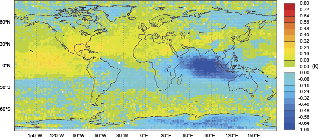
Figure 1: In early September, METOP-A satellite data showed an anomaly in infrared observations at the wavenumber 713 cm-1 (corresponding to a wavelength of 14 microns) over the Indian Ocean. The chart shows monthly mean values for the period 15 September to 15 October 2015.
The instruments on board these satellites are designed primarily to provide information on variations of temperature and humidity by measuring fluctuations in the natural thermal radiation emitted by the Earth’s atmosphere. However, it soon became clear from the spectral characteristics of the signal that this anomaly could not be attributed to any meteorological event.
The timing of the anomaly coincided with widely reported wildfires in Indonesia and it became likely that the cocktail of gases and particulate pollutants produced by these fires was contaminating the satellite measurements. After eliminating many possible chemical species Hydrogen Cyanide gas (HCN) soon emerged as the prime suspect. This pollutant is a well-documented product of peat based biomass burning (a feature of the Indonesian fires) and its known spectral fingerprint exactly matched that of the anomalous radiance signal detected in the satellite observations.
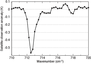
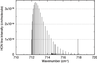
Figure 2: Spectral characteristic of the observed satellite anomaly showing the satellite measurement depletion (left); and spectral fingerprint of HCN determined from laboratory measurements showing the strength of HCN absorption (right).
As soon as the source of the anomaly was confirmed, NWP centres around the world acted on the NWP-SAF alerts and immediately removed the affected channels from their operational data assimilation systems.
Under these extreme conditions (more than 20 times the background concentration of HCN) continuing to use these data could have caused significant damage to operational forecasts.